Rising sea set to swallow Chennai's Island Ground, Pallikaranai marshland
According to the 'Sea Level Rise Scenarios and Inundation Maps for Selected Indian Coastal Cities' report released by CSTEP, the sea level in Chennai would rise by 94.7 cm by 2100 under the high-emission scenario.;

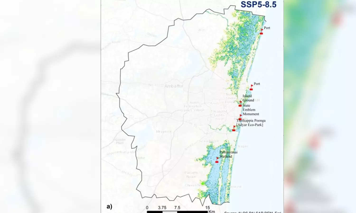
Map of Chennai indicating the sea level rise
CHENNAI: Imagine a Chennai without Island Ground, Adyar Eco-Park, or the Pallikaranai marshland. Imagine a tomorrow when these major landmarks that define the Chennai as we know it are under sea. This is not a product of mere imagination, like the ‘catastrophe porn’ that Hollywood revels in, but a clear and distinct warning for what awaits your sons and daughters in the coming decades.
This bleak picture wherein the sea will rise by nearly one metre is part of the forecast by the Centre for Study of Science, Technology and Policy (CSTEP). Sure, there are sceptics and even climate change deniers who are not convinced by such doomsday predictions. Here is a sobering shot of reality for them (and the rest of us): Chennai recorded a sea level rise of 0.67 cm between 1987 and 2016, which works out to an annual rise of 0.066 cm.
Now, take out the calculator and do the math (0.066 cm multiplied by X number of years). And then, factor in a bit of physics: the increasing rate at which polar ice is melting into water. Add a dash of climate science, what we have is not a recipe for disaster but the tale of one foretold.
What the report says
According to the 'Sea Level Rise Scenarios and Inundation Maps for Selected Indian Coastal Cities' report released by CSTEP, the sea level in Chennai would rise by 94.7 cm by 2100 under the high-emission scenario (known among experts and scientists as SSP5-8.5).
In this scenario, Chennai’s sea level would rise by 18.7 cm by 2040; 32.7 cm by 2060, and 64.9 cm by 2080.
What would be the effect of this rise? Of the present spread of the Chennai Metropolitan Area (CMA), nearly one-fifth would be under water by 2100 if the regimes here and across the world allow the high-emission scenario to continue. To put that in actual terms, 215.77 square km of CMA – 18.15% of the area to be precise – would be underwater by the end of the century.
The inundation numbers for the intervening years are 86.77 sqkm (7.30%) by 2040, 119.48 sqkm (10.05%) by 2060, and 159.28 sqkm (15.11%) by 2080.
What if we cut down on emission?
Now, what if the decision-makers of the world grow wise and pull back the emissions to the low-emission scenario (SSP2-4.5 scenario)? Unfortunately, that too is far from rosy, as the study warns that the city would witness a sea level rise of 71.2 cm by 2100.
In this scenario, Chennai may witness 17.4 cm, 32.7 cm and 51 cm of sea level rise by 2040, 2060 and 2080, respectively. This would mean 207.04 sqkm of CMA (16.90% of the total area) will be inundated by 2100.
The progression of inundation offers an insight into the compounding effect of climate change. The situation in 2040 would be the almost same in low and high-emission scenarios (86.6 sqkm or 7.29%), marginally better in 2060 (114.31 sqkm or 9.65%), slightly better in 2080 (154.66 sqkm or 13.01%).
"All land use land cover (LULCs) would be affected by sea level rise by the end of the century. Adyar Eco-Park, Island Grounds, State Emblem Monument, and Pallikaranai wetland and port would be at high risk, with notable areas under habitation and waterbodies," the report said.
Chennai is not alone:
Chennai is not the only mega city facing the risk - 1,055 sqkm and 1,377 sqkm of Mumbai will be inundated due to sea level rise by 2100 under the low and high-emission scenarios, respectively.
Similarly, sea level rise in Kanniyakumari and Thoothukudi has been projected to be at 99.3 cm and 92.2 cm under the high-emission scenario.
HIGH-EMISSION SCENARIO
Sea level rise – Year
18.7 cm – 2040
32.7 cm - 2060
64.9 cm – 2080
94.7 cm - 2100
Between 1987 and 2016, Chennai’s sea level rose by 0.67 cm

