Cyclone Fengal ‘very likely’ by November 27. Will it hit Chennai? Weathermen track ‘cone of uncertainty’
Several parts of Chennai and Tamil Nadu received moderate to heavy spells of rain on Tuesday morning.;

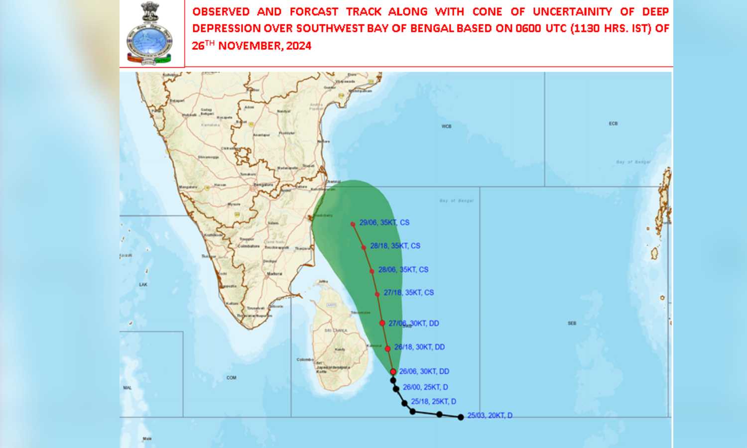
The cone of uncertainty is marked in green (X/IMD)
CHENNAI: Officials from the India Meteorological Department (IMD) and weather bloggers in Tamil Nadu are closely tracking the deep depression that is hovering over southwest Bay of Bengal beyond Sri Lanka. There are two questions in their minds: Is it going to intensify further and become a cyclone? If it does become a cyclone, what does the ‘cone of uncertainty’ reveal about the location where it would make the eventual landfall?
Also Read:Rains lash several parts of Chennai, deep depression likely to intensifyMeanwhile, several parts of Chennai and Tamil Nadu received moderate to heavy spells of rain on Tuesday morning. The weather department issued orange alerts for some of the Delta districts indicating very heavy rains.
Even as rains lashed many places across the State, the professional weathermen’s primary attention is lying 770-plus km away. There in the Bay of Bengal is the weather system that strengthened from a depression to deep depression on Tuesday morning (November 26).
As of 11.30 am on Tuesday, it was situated around 770 km away south-southeast of Chennai and moving at a speed of 12 km per hour.
A deep depression is a system that is one step away from being a cyclone. If that intensification indeed happens and the deep depression becomes a cyclone, it would be named Cyclone Fengal, a name that Saudi Arabia has proposed.
The map prepared by the IMD shows that the deep depression took a sharp turn north-northwestwards, and as per the prediction models that the weathermen are following, it is “very likely to continue to move north-northwestwards and intensify further into a cyclonic storm on November 27,” the IMD said in a bulletin on Tuesday.
Going by the forecast, the system would skirt Sri Lanka and continue to move towards the Tamil Nadu coast in the next two days. Now, this is where the cone of uncertainty lies.
Tropical weather systems are complicated and complex due to the various factors that affect them, which often leave weathermen at the receiving end of jokes and memes when their forecast does not come true. As they repeatedly clarify, the path that a cyclone would take can only be predicted – and not ascertained with pinpoint accuracy.
These models leave a wide margin for change as the storm gathers strength and gets affected by different factors. As per the present forecast, the cyclone-in-the-making looks headed right toward Chennai, but the eventual landfall could be anywhere between Puducherry and Chennai, or even beyond the State borders and go to Andhra Pradesh.

